STAY CONNECTED: Have the stories that matter most delivered every night to your email inbox. Subscribe to our daily local news wrap.
While snowpack levels have increased slightly from April to May, they're still at the second-lowest level ever recorded in B.C., with the provincial government encouraging residents to start conserving water. (File photo/NanaimoNewsNOW)
still low snow

Island snowpack levels remain low in May despite small April increase

May 10, 2024 | 2:40 PM

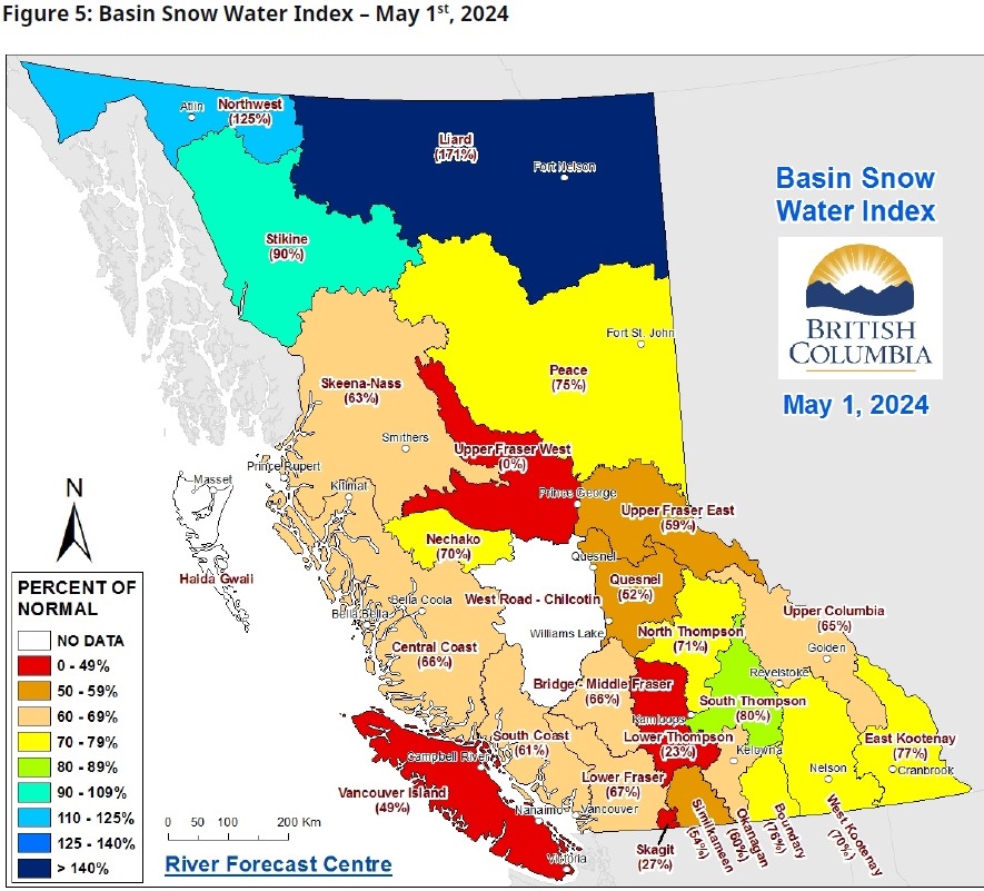
NANAIMO — While up slightly compared to April, the snowpack level across B.C. remains incredibly low, with no change occurring on Vancouver Island.

The May 1 snow survey and water supply bulletin indicates the average Vancouver Island snowpack was 49 per cent of normal for this time of year, unchanged since April.

Minister of water, land, and resource stewardship Nathan Cullen said with little precipitation predicted in the immediate forecast, they are taking these low levels very seriously.

“Snowpack levels, which are a critical part of British Columbia’s ability to have enough water, which come most from the spring, summer and right through the fall, are historically low right now at 66%. That is a significantly low snowpack that we’re dealing with.”

Current provincial snowpack levels match those recorded in March, with both months tied for the second-lowest levels on record.

It’s a three per cent increase from April, when snowpack levels were at their lowest average amount since 1970.

Last year, the May 1 was 91 per cent of normal.

The Upper Fraser West area is reporting the lowest levels of mountain snow at zero per cent, while the Liard snow basin in the northern part of the province is at the highest at 171 per cent of normal.

Vancouver Island currently has the fifth lowest snowpack levels, ahead of the Nicola-Thompson basin (34 per cent, Skagit (south of Hope, 27 per cent), and the Lower Thompson sub-basin of the Middle Fraser (23 per cent).

Across B.C., 16 stations are currently at record low levels, including the Upper Fraser East, Quesnel, and West Kootenay.

According to the bulletin, the slight increase is largely due to a delay in snowmelt instead of more snow falling, with lower elevations such as the Interior being completely snow-free.

Cullen said the fact much of the province is experiencing less than average or no snowpack at all is very concerning as we head into the warmer months.

“Overall BC continues to get less rain and snow than usual, and that’s having a lasting impact on water levels right across the province. We experienced severe drought last year and remain at high risk going into the season.”

Temperature across the province in April was about average, with the Island getting almost the regular amount of rain.

Despite the precipitation, the rain did little to dampen the wildfire concerns amid the ongoing drought conditions.

A bit of snow and a cooler April helped maintain or add to the snowpack levels in areas of B.C., but at 66 per cent of average, it’s still tied for the second lowest levels on record. (B.C. River Forecast Centre)

Join the conversation. Submit your letter to NanaimoNewsNOW and be included on The Water Cooler, our letters to the editor feature.

jordan@nanaimonewsnow.com

On Twitter: @JordanDHeyNow