STAY CONNECTED: Have the stories that matter most delivered every night to your email inbox. Subscribe to our daily local news wrap.
Snowpack levels across B.C. are at the lowest levels seen since 1970 when stats were first collected, with Vancouver Island recording the second-lowest percentage in the province for April 1. (File photo/NanaimoNewsNOW)
lowest levels ever

Snowpack in B.C. at lowest level since 1970

Apr 10, 2024 | 1:05 PM

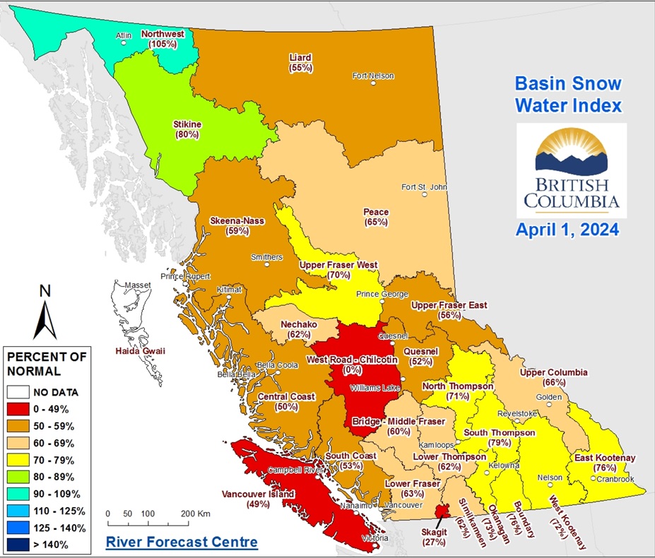
NANAIMO — Snowpack levels in B.C. mountains are at their lowest point in more than 50 years, with Vancouver Island reserves among the lowest in the province.

The April 1 snow survey and water supply bulletin shows the Island at only 49 per cent, an increase of 3 per cent from March, when snowpack levels reached their second-lowest point in provincial history.

Hydrologist with the river forecast centre Jonathan Boyd said despite Vancouver Island having the second-lowest snowpack in the province, none of their measurements were at record lows.

“This is including the South Coast which is at 53 per cent of normal…the lowest year recorded for these regions was 2015 when the South Coast was 13 per cent of normal and Vancouver Island was 15 per cent of normal for April 1. So the snowpack is considerably higher than it was in 2015 on the Island.”

B.C. is averaging 63 per cent of snowpack right now, while the provincial average at this time last year was 88 per cent.

Skagit, south of Hope, was the lowest at only 27 per cent, while the Northwest basin is the highest at 105 per cent. Nearly all snow basins are at or below 80 per cent of normal.

The Skagit area east of the Fraser Valley had the lowest average snowpack in the province for April 1 at 27 per cent, followed by Vancouver Island at 49 per cent.The Chilcotin area had insufficient data needed. (B.C. River Forecast Centre)

Cool and dry conditions continued to persist throughout March with the mid-Island only seeing about half of March’s regular rainfall, further adding to the water deficit which has been persisting since last year.

Boyd said while these conditions should reduce the risk of flooding due to fast snowpack melt, local flooding due to extreme rainfall is still possible.

“It’s especially noticeable in the larger systems like the Fraser River, Thompson River… a silver lining of this low snowpack is that areas that have been impacted consistently by flooding in recent years will have a lower risk this spring.”

He said smaller to medium-sized rivers in the interior also carry a potential flood risk, as spring is typically their wettest season.

Vancouver Island is still at drought level one according to the B.C. drought information portal, but the environment is much drier in the northern and western parts of the province.

Weather experts have continued to predict a warmer-than-average spring and summer, while seasonal precipitation levels are more difficult to anticipate.

However, the province’s snow and water supply report indicated current precipitation projections for April to June suggest a small likelihood of below-normal precipitation levels across Vancouver Island.

Join the conversation. Submit your letter to NanaimoNewsNOW and be included on The Water Cooler, our letters to the editor feature.

jordan@nanaimonewsnow.com

On Twitter: @JordanDHeyNow