LOCAL NEWS, DELIVERED DAILY. Subscribe to our daily news wrap and get the top stories sent straight to your inbox every evening.
An atmospheric river system settled over the province Sunday evening, with upwards of 200 millimetres of rain expected in areas of western Vancouver Island by Wednesday morning. (Image Credit: File photo/NanaimoNewsNOW)
atmospheric river

Nanaimo and Oceanside expected to be spared worst of extended downpour

Mar 16, 2026 | 12:10 PM

NANAIMO — Much of B.C. woke up Monday morning to wet and windy conditions as an atmospheric river storm system touched down over the weekend.

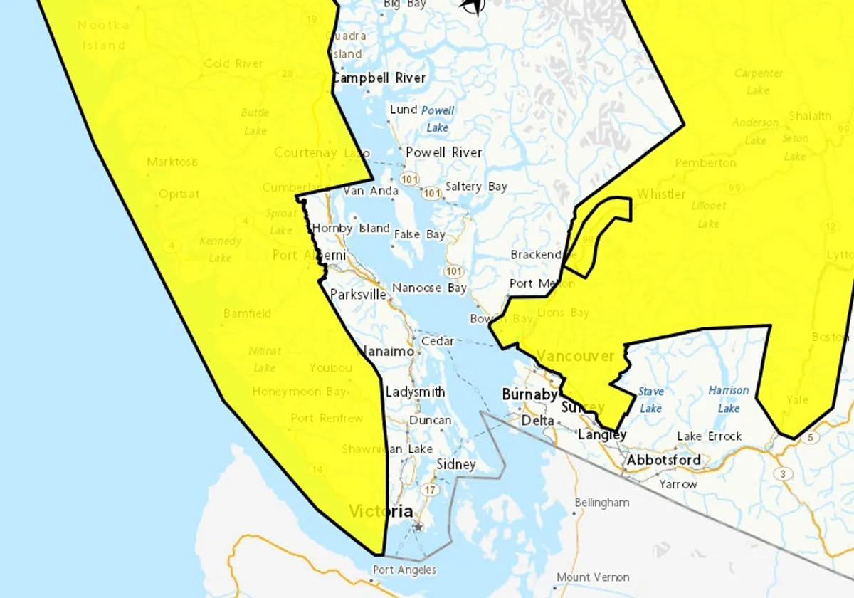
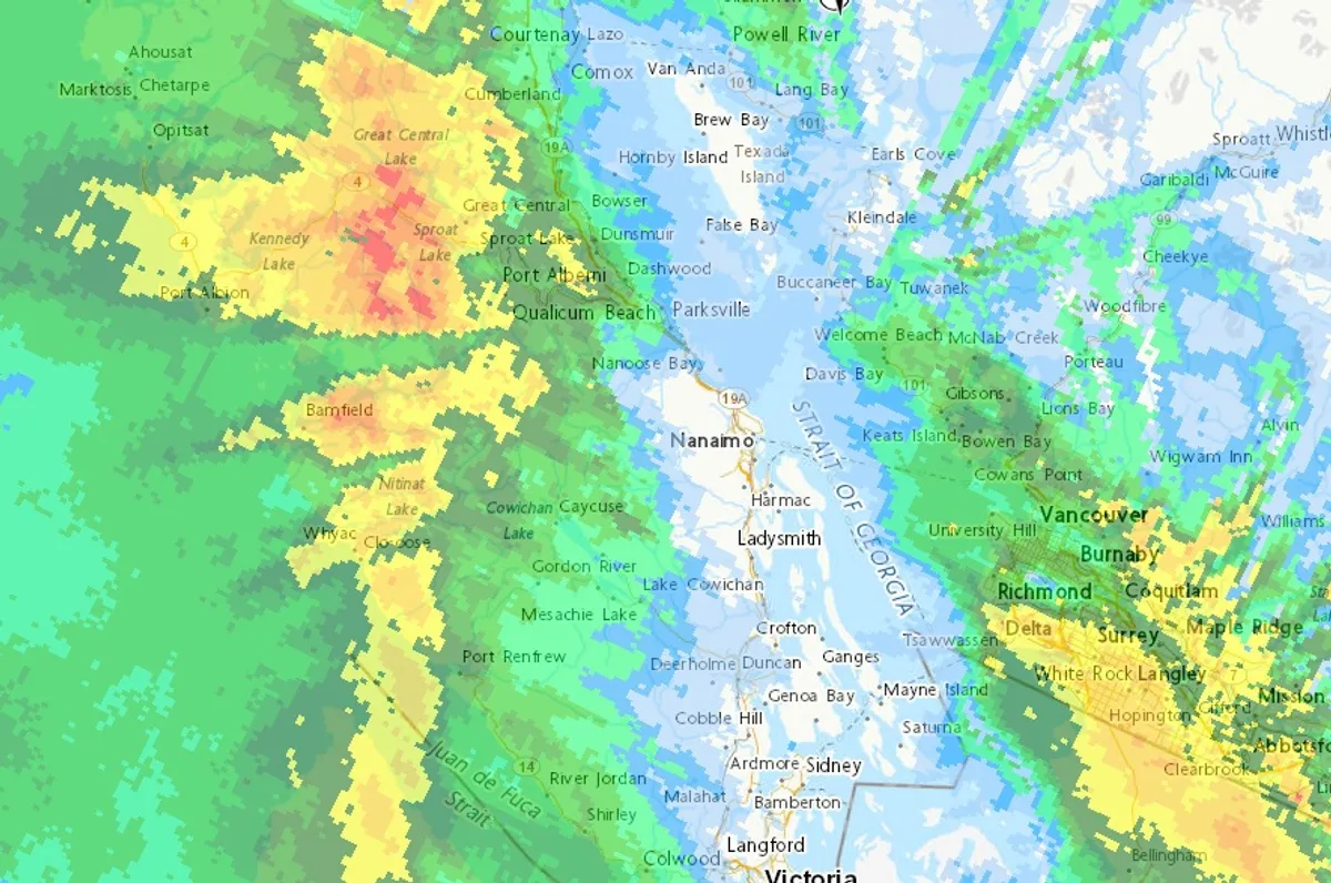
Rainfall warnings are in place for much of central and western Vancouver Island, with 100-150 millimetres expected between Monday, March 16 and Wednesday, March 18, while some areas could see as much as 200 millimetres.

Environment Canada meteorologist Brian Proctor said the system should remain fairly contained to those areas, which have already seen a significant amount of rain since Sunday evening.

“Heavy rainfall over the central coast, heavy rainfall on the west side of Vancouver Island, and coming down the northern portion of the Island. Probably getting into the Campbell River area, but areas further south on the east side of the island aren’t going to see near as much in that way of heavy precipitation.”

Between five and 10 millimetres of rain is expected in Nanaimo by Monday evening, with 15 to 25 millimetres expected for Oceanside.

The east coast of Vancouver Island, south of Denman Island, did not have any weather warnings in place as of 11 a.m. Monday morning, with orange rainfall warnings in place for the west coast, including Tofino and Ucluelet, with high impacts expected due to the rain.

The northern tip of Vancouver Island, north of Sayward, also upgraded their alerts from yellow to orange.

“Up in the Cathedral Point (midway between Bella Bella and Bella Coola) area up on the central coast, they’ve been receiving between five and six millimetres of precipitation every hour for 14 hours consecutively now, and really we’re looking at that sort of rainfall continuing and sort of spreading down the coast over the next 72 hours,” Proctor said.

Rainfall warnings are in place for much of Vancouver Island, save for the mid and lowest eastern portions as of 11 a.m. Monday, March 16.
Rainfall warnings are in place for much of Vancouver Island, save for the mid and lowest eastern portions as of 11 a.m. Monday, March 16. (Image Credit: Environment Canada)

He added the rain, combined with higher-than-average temperatures brought in by the atmospheric river this week, is likely to have major impacts on our snowpack levels.

As of March 1, Vancouver Island had the lowest levels of mountain snow in the province at 48 per cent, compared to a province-wide average of 91 per cent.

The B.C. River Forecast Centre issued a high streamflow advisory in place for eastern Vancouver Island from Victoria to north of Courtenay on Monday morning, while the west coast and northern part of the Island is under a flood watch.

“It’s really pushing freezing levels up, and fairly substantially upwards,” said Proctor. “From (Mon) morning, the freezing levels were probably 700 metres over the island, and I think we’ll be pushing them up about 2,000-2,500 by the end of the afternoon, early this evening, then they are going to stay high right through this atmospheric river event.”

Daytime temperatures between 12 and 14 degrees Celsius are expected in the Nanaimo and Oceanside area until Thursday, before conditions gradually return to normal by the weekend.

Weather warnings in place for Metro Vancouver, the Sunshine Coast, Howe Sound and elsewhere are calling for prolonged heavy rain that could mix with snow in some areas, swelling rivers and causing potential flooding.

Environment Canada’s yellow warnings said the weather system could cause extensive pooling on roads, and increase risks of landslides in areas with unstable slopes, such as lands scarred by past wildfires.

Snowfall warnings were in place across the Mainland and northern areas of the province, with 10-15 centimetres expected in the Fort Nelson area.

B.C.’s north coast, covering Kitimat to Terrace, could see up to 30 centimetres of snow before turning into rain, with upwards of 70 millimetres expected by Wednesday.

Weather radar as of 9:00 a.m. on Monday, March 16, shows the weather system with heavy rain moving east across Vancouver Island.
Weather radar as of 9:00 a.m. on Monday, March 16, shows the weather system with heavy rain moving east across Vancouver Island. (Image Credit: Environment Canada)

With files from The Canadian Press.

Local news. Delivered. Free. Subscribe to our daily news wrap and get our top local stories delivered to your email inbox every evening.

info@nanaimonewsnow.com

Follow us on: Twitter (X) | Bluesky | Facebook