LOCAL NEWS, DELIVERED DAILY. Subscribe to our daily news wrap and get the top stories sent straight to your inbox every evening.
Vancouver Island still has the lowest average snowpack levels in the province at 27 per cent of normal as of May 1, while the provincial average is at 83 per cent. (Image Credit: File Photo/NanaimoNewsNOW)
low snow

‘About as bad as it could be:’ scarce snow increasing mid-Island drought concerns

May 11, 2026 | 12:22 PM

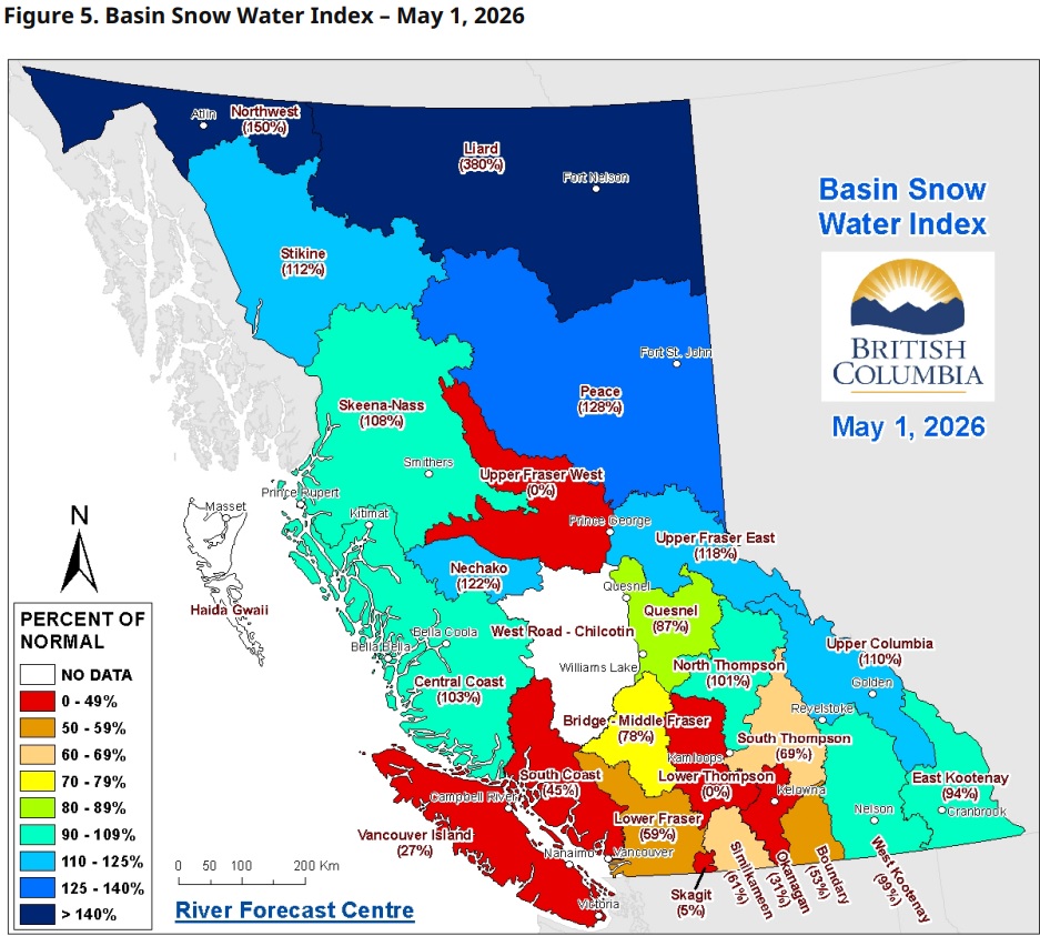
NANAIMO — Mountain snowpack levels on Vancouver Island continue to be one of lowest in the province, a steep decline compared to this time last year.

According to the May 1 report from the Ministry of Water, Land, and Resource Stewardship, Vancouver Island is currently at 27 per cent of its regular levels, down from 44 per cent in April, and much lower than the 70 per cent recorded this time last year.

Hydrologist with the BC River Forecast Centre Jonathan Boyd said this is some of the most rapid melting of mountain snow they’ve ever seen on Vancouver Island.

“That’s just because of the warm weather that we constantly had to start May, and in particular, it was really accelerated last week on Sunday and Monday when we had record-breaking temperatures for the day of the year for a lot of locations.”

Nanaimo is coming off one of the warmest and driest Aprils on record, with the mid-Island already breaking daily high-temperature records to start off May.

Province-wide, the story is less severe this year, with 83 per cent of mountain snow remaining on May 1, a decrease of 11 per cent from April 1.

The May 1 report shows a clear divide in mountain snowpack levels throughout the province, with the north having potential flooding concerns, while the central and southern areas are worried about possible drought conditions.
The May 1 report shows a clear divide in mountain snowpack levels throughout the province, with the north having potential flooding concerns, while the central and southern areas are worried about possible drought conditions. (Image Credit: Ministry of Water, Land, and Resource Stweardship.)

The report said B.C. typically reaches maximum snow accumulation levels by mid-April, with snowmelt trending earlier than normal, with 15 per cent of peak total snowpack melting by May 1, and approximately 28 per cent by May 7.

The contrast of mountain snow levels is sharp between different areas of B.C., with the Lower Thompson and Upper Fraser West reporting zero per cent of their mountain snowpack levels, while the Liard region around Fort Nelson is at 380 per cent of normal.

Boyd said 2015 was a benchmark drought year for Vancouver Island, with only around 15 per cent of mountain snow remaining on April 1.

While we’re not at those concerning levels yet, Boyd is hoping for a few major rainfall events in May, or perhaps a wet and cool ‘Juneuary’ to replenish the islands’ water reservoirs.

“But right now, in terms of the baseline…conditions as we move into the spring and summer, this is about as bad as it could be. The only thing that would be worse is if the snowpack was even worse and lower, and if the temperatures were even warmer.”

He said stream and creek water levels are very low right now, raising drought concerns as we look ahead at the summer months.

“Traditionally, Vancouver Island rivers and creeks get to their lowest in late-July through August and September, and that’s where they’re most at-risk for ecosystem habitat where fish aren’t able to sustain, literally their lives, just because the temperature of creeks can get so warm when water is shallow, and air temperature is hot.”

Low snowpack levels, early snowmelt, and warm seasonal weather forecasts are increasing drought concerns for the Island, as well as on the southern coast and in the southern interior.

— with files from Jon de Roo, 97.3 The Eagle

Local news. Delivered. Free. Subscribe to our daily news wrap and get our top local stories delivered to your email inbox every evening.

info@nanaimonewsnow.com

Follow us on: Twitter (X) | Bluesky | Facebook