LOCAL NEWS, DELIVERED DAILY. Subscribe to our daily news wrap and get the top stories sent straight to your inbox every evening.
The snow has long been melted on most mountains on Vancouver Island, with a similar trend seen across the province. (File Photo)
hot and dry

Summer drought risk increases as hot weather melts mountain snow

Jun 11, 2025 | 4:26 PM

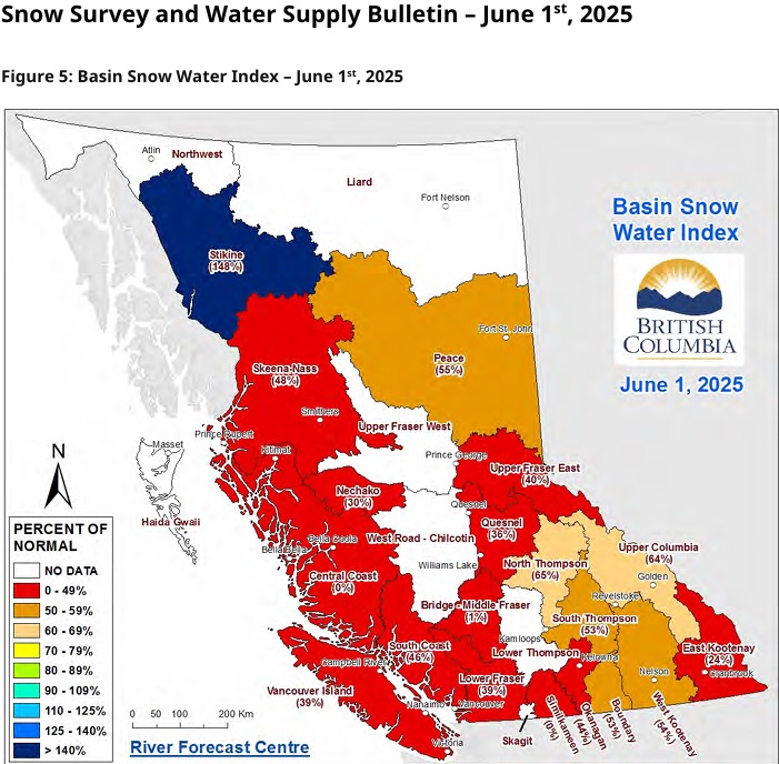
NANAIMO — The chances of drought conditions for B.C.’s summer continue to increase, according to the most recent look at mountain snowpack levels impacting water supply.

The June 1 snow survey and water supply bulletin indicates Vancouver Island has only 39 per cent of its average snowpack, a dramatic decrease from 70 per cent on May 1.

Dave Campbell with the BC River Forecast Centre said the trend of below-normal snowpack levels continued province-wide, with B.C.’s snowpack levels at 44 per cent for June, down from 71 per cent at the start of May.

“Generally, across the province, we came into the season low, and we’ve reached the peak of the snow accumulation around the middle of April, April 14, and have been subsequently melting that snow off as we go through.”

The current numbers are an increase from June 2024 for Vancouver Island, when only 31 per cent of the average snowpack levels remained, according to the report.

Province-wide, however, it’s a decrease from last June’s total of 57 per cent.

Only a few regions in B.C. currently have an equal or lower snowpack percentage than Vancouver Island, including Lower Fraser (39 per cent) Nechako (30 per cent), East Kootenay (24 per cent), and Middle Fraser (19 per cent).

The Similkameen and Central Coast regions are reporting zero per cent of their snowpack remaining.

While the Stikine region in the province’s northwest was the only area with more snowpack than average at 148 per cent, only West Kootenay (54 per cent) and the Peace (55 per cent) were above half.

Campbell said on average, approximately half the seasonal snowpack has melted by June 1. However, so far this year, two-thirds have melted, driven by a warmer-than-average April and hot weather in the final week of May, specifically in the Interior.

“We’re really getting into the advanced stages of the snowmelt freshet at this point with the monitored sites around the province that really only have about a week or so left of snow. Obviously, at the higher elevations that snow is going to continue to linger as we go through the month.”

While the low snowpack reduces the risk of spring flooding, the early melt and warm seasonal forecasts for the summer are pointing to increased drought hazards in the coming months.

Warm and dry spring weather helped contribute to the melting snowpack in B.C., with the majority well below their average levels for June 1. While the risk of spring flooding is greatly reduced, the chances of drought-like conditions this summer are high. (B.C. River Forecast Centre)

Join the conversation. Submit your letter to NanaimoNewsNOW and be included on The Water Cooler, our letters to the editor feature.

jordan@nanaimonewsnow.com

On Twitter: @JordanDHeyNow