STAY CONNECTED: Have the stories that matter most delivered every night to your email inbox. Subscribe to our daily local news wrap.
Weather patterns shifted dramatically lately, leading to multiple rainfall events. (file photo/NanaimoNewsNOW)
here comes the rain

Notable injection of rain falls following long dry stretch

Aug 19, 2024 | 4:48 PM

NANAIMO — A lengthy stretch of summer-like conditions has given way to recent rains on the mid Island, with additional precipitation expected.

According to Environment Canada, 12.3 millimeters (mm) of rain fell at Nanaimo Airport on Sunday, Aug. 18 with more expected to fall this week.

Meteorologist Derek Lee said upwards of 30 mm of rain could hit the region by end of day Wednesday.

“Wednesday is probably when we have the biggest chance of something more organized with 10 to 15 millimeters for east Vancouver Island,” Lee said.

Unstable recent weather patterns featured a pair of thunderstorms bringing rain to the region overnight Saturday and Sunday afternoon.

Environment Canada has the possibility of an additional round of a thunder for much of Vancouver Island, including the mid Island area, on Tuesday afternoon.

“Thunderstorms can always bring us a locally heavier precipitation.” Lee said.

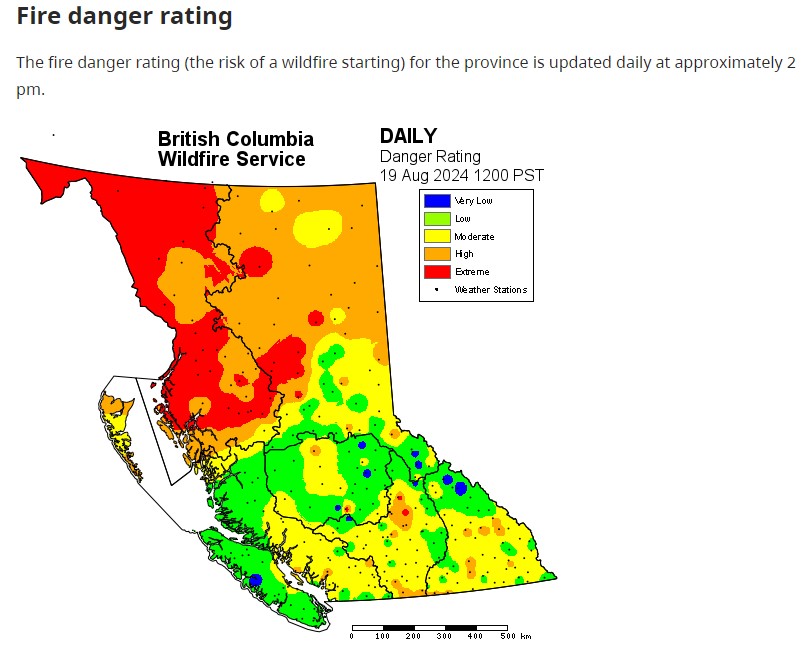
After the mid Island’s fire danger rating was entrenched in the high to extreme range for several weeks, cooler temperatures lowered the threat considerably to low by Monday afternoon, according to the BC Wildfire Service.

The fire danger threat in the mid Island region has dropped from the high/extreme range to low in a matter of a few days. (BC Wildfire Service)

Join the conversation. Submit your letter to NanaimoNewsNOW and be included on The Water Cooler, our letters to the editor feature.

info@nanaimonewsnow.com

On Twitter: @NanaimoNewsNOW