STAY CONNECTED: Have the stories that matter most delivered every night to your email inbox. Subscribe to our daily local news wrap.
Joey Pillott moves slushy snow at the top of Rutherford Rd. in north Nanaimo the morning of Monday, Jan 8., as the mid-Island received its first blast of wintery weather for the season. (Ian Holmes/NanaimoNewsNOW)
slushy snow

‘Not the main event:’ blast of winter weather brings slushy mess to Nanaimo area

Jan 8, 2024 | 11:24 AM

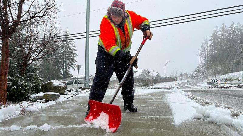
NANAIMO — Parts of the Nanaimo area saw a blanket of wet, slushy snow Monday morning as the first winter storm of the season touched down overnight bringing a mix of snow flurries, rain and wind.

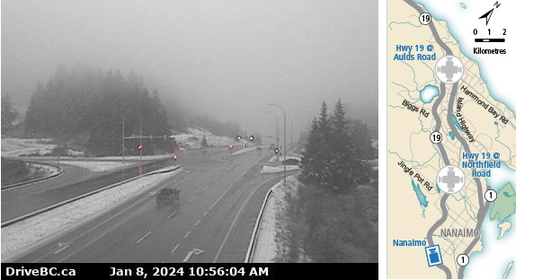
A snowfall warning was issued for eastern Vancouver Island on Monday, Jan 8 around 5 a.m. with about 10 centimetres of snow expected in higher elevations by the afternoon, and between two and four centimetres at sea level.

Environment Canada warned sections of the central and south coasts of B.C. will be hit hardest with a rain/snow combination, with sea-level areas of eastern Vancouver Island also expected to see some snow build up.

Road conditions across the mid-Island were mostly clear Monday morning, however, strong wind warnings and potential for snow accumulation have been called for in sections of the Malahat Hwy. closer to Victoria.

Few traffic disruptions have been reported in Nanaimo as of late Monday morning, with traffic moving slowly and cautiously, especially in areas of higher elevation along Hwy. 19.

Due to its elevation, Hwy. 19 at College Dr. has visible roadside snow accumulation and slushy sections. (Drive BC)

The storm is expected to transition coastal snow into rain by Monday afternoon, with western parts of the Island bearing the brunt of strong winds.

Mainroad Contracting has their snow-moving trucks and deicers out in full force on regional highways on Monday, according to manager Chris Cowley.

“Throughout today (Monday) we got a fleet of trucks out just cycling the highway and keeping the snow levels down where they might be accumulating. so far it’s not too bad, the road temperatures are still fairly warm, so it’s not sticking to the point where we are having trouble getting it off.”

Cowley said there could be challenges for motorists depending on location with the temperatures hovering around the freezing mark on Monday.

“Warming temperatures is great, makes the snow and ice easier to get off the roads, but we do have little micro-climates here and there and little pockets of higher elevation, so just because it warms up and the roads look good we could still see some icy conditions.”

Additional snow could fall later this week, coupled with cooling temperatures Thursday through Saturday with daytime highs below the freezing mark.

BC Hydro is also getting ready for the chance strong winds combined with heavy snow could damage power lines Monday afternoon and into the overnight.

Hydro’s Ted Olynyk said they prepare year-round for events just like this, and their crews are ready to head out in the event of a downed power line or outage.

“We recommend our customers make sure you’ve got your emergency kit handy, make sure you’ve got a plan. Not only is it going to be strong winds but it’s going to be cold.”

You can check out any power outages in your area by clicking here to go to BC Hydro’s outage map.

Later in the week: cooling down and more snow
Environment Canada meteorologist Armel Castellan said this early week blast of winter is “not the main event” weather-wise with more wintry conditions expected by the weekend.

“Tomorrow (Tuesday)… we start to cool off slowly, and then dramatically Wednesday, Thursday, there’s a possibility of seeing what we call ‘strait effect snow’. Kind of like what the Great Lakes see when cold air streams over a water body. It doesn’t need to be fresh water like the Great Lakes in Ontario… it picks up moisture and then gives an area on the eastern side of Vancouver Island some snow.”

Castellan said by Thursday evening, Artic air will be hitting the B.C. coast, expecting to drop the temperature by almost 10 degrees below seasonal.

“And then we’ve got the conditions where the cold is now settled in, and eventually the Pacific will have an impasse and start to feed moisture into that cold environment. Those are the kinds of cases where we would see a bigger snow event right down to sea level.”

— with files from Jon De Roo/97.3 FM The Eagle

Local news. Delivered. Free. Subscribe to our daily news wrap and get our top local stories delivered to your email inbox every evening

info@Nanaimonewsnow.com

On Twitter: NanaimoNewsNOW